Old Scotch Road
We left our Drover and his herd of cows at Lowgill. From this point the main droving route turned right and climbed up onto the fellside. The road here is wide and has deep verges, tell-tale signs that this was an old droving road. But there is further evidence, as this road has been named on maps since the 1800s to the present day as Old Scotch Road. Because of course, as we now know very well, this was one of the main ways that cattle was brought down from Scotland to the south of England. It is also known as Galwaithgate, which is a more specific reference to the fact that much of the cattle would have been coming from the Lowlands of Scotland – Galloway, which is where we started this whole journey.
The bit of Old Scotch Road that we are now at is known as Lambrigg Park and there is a fair amount of evidence to suggest that this was a popular resting point for drovers. It was a good distance to have travelled from the last point, there was plenty of pasture and it was high up, so less risk of thieves ambushing.
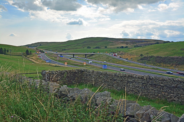
It was here that Andy Goldsworthy next built his arch - in this sheepfold and actually on the Scotch Road itself. It cannot have escaped your notice though that it is no longer quiet and peaceful up here, as it would have been. Something came along, that something being the M6, here seen down below and certainly heard by us from where we were. It’s the main motorway taking vehicles north to Carlisle and then onto Glasgow and Edinburgh and the rest of Scotland. It runs more or less parallel with the old road that we were on.
This is actually the M6 junction for Sedbergh and Kendal, so if you are travelling this way and notice a road high above you, you now know what it is. We’re off on the M6 north tomorrow.
Comments
Sign in or get an account to comment.


