
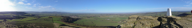
Roseberry Topping panorama
As a radio ham, I often operate my radio in support of charity walks. This one, called CSRT (Cleveland Search and Rescue Team) Survival, was 24 miles over rough terrain. I was used at the first checkpoint on the top of Roseberry Topping, a local high point and at the last checkpoint, at the base of Roseberry Topping. While on the top, I used the HX5V's Intelligent Sweep Panorama to take this breathtaking shot around the hill.
164
views
- 0
- 0
- Sony DSC-HX5V
- f/3.5
- 4mm
- 125
Comments
Sign in or get an account to comment.


