
The Bavarian Arch
I needed to get myself moving today. The weather was mostly grey continuing cold. It was necessary to wrap up warm. Basil wore his fleece, I put on my Baker's cap. Despite that, we still didn't leave the house until after 3 pm. I did get round to cleaning the floor of my shower. Where does all the hair and grease come from?
Carol had walked on Garendon Estate two days ago and I had noticed among her photos, a shot of the Bavarian Gate. Len drove us to the end of Blacksmiths Avenue adjacent to Butthole Lane which thankfully saved us a mile or so.
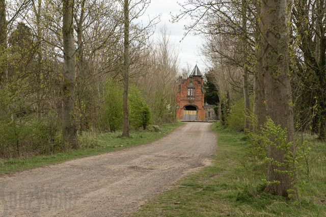
I didn't really know where the gate was so Baz and I kept on walking. The path is a bridle way and is part of a national cycling route. The gate wasn't where I thought it was. We simply carried on, until I spotted, in the distance, a red brick building. I had to keep putting Basil on his lead because farm workers were spreading fertiliser on the field. A tractor made repeated visits to a farm building to replenish supplies.
Eventually we reached a t-junction. Google maps told me the bar of the T was Hathern Drive. I could see the track/road was fairly straight, lined with trees (identity unknown but they reminded me of poplars), and led straight to the arch. The gate closing off the entrance has been replaced by shoddy pieces of timber.
Yet this is a Grade II listed building that was designed by William Railton in 1838. Railton is best known for having designed Nelson's Column. I don't know if this was the main approach to the park. I am aware of other entrances, notably Coach Road near me which passes under the M1.
Looking at Google Maps, I realised we had almost made it to Stonebow Bridge.
Comments
Sign in or get an account to comment.


