Project 365 day 136: Europe in 1924
This is the penultimate map from my mother’s copy of Philips’ Intermediate Historical Atlas for Schools, tenth edition, 1939. She started grammar school as Britain declared war on Germany, a ten year old scholarship girl, orphaned only two years before, taking the long daily bus ride into Ormskirk from the village where she was living with her aunt and uncle. I think she was the only pupil from the village school to pass the scholarship exam that year; her sister, seven years older, had been sent into service as a scullery maid when their mother died.
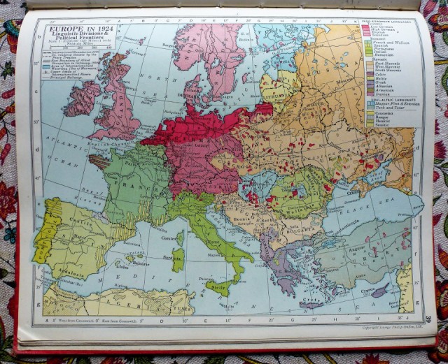
The atlas contains a fascinating collection of maps. The map of Europe in 1924 shows the post-Versailles political borders, as well as some of the former ones, but the colours are based on linguistic groups. I wanted to look at Prussia and the changing borders along the Baltic coast: on this map, East Prussia is the furthest patch of deep red to the right, close to Lithuania. P was reading about exclaves, for reasons I didn’t grasp, and told me about the Kaliningrad Oblast, an exclave of the Russian Federation sandwiched between Poland and Lithuania, at some distance from the Russian border. I was unclear why this territory should be part of Russia, and further confused to be told it had previously been the German city of Königsberg, birthplace of Kant, Hoffman and Käthe Kollwitz. It was a medieval city which became the capital of East Prussia, ruling a substantial area of the Baltic coast and hinterland; I should have remembered from my excellent O level course in twentieth century history that in 1919 the Treaty of Versailles designated Danzig (now the Polish port of Gdansk but then also part of East Prussia) as a free port and created the “Polish Corridor” running through Prussia to Danzig to give Poland access to the sea. This is visible on the map a little further west. I don’t know if there was a widespread sense of grievance about the consequent loss of territory and separation of Königsberg from the rest of Germany, but in the 1930s the region seems to have proved particularly fertile ground for Nazism. In 1944 much of the old city, with its cathedral, castle and two universities, was destroyed by British bombing; early in 1945 Nazi troops were besieged by the Red Army for three months before surrendering the city. In 1945, under the post-war redistribution of territory agreed at Potsdam, the Soviet Union first administered and then annexed the city and region; they promptly forced what remained of the German population to leave, changed its name, and repopulated the city with 400,000 people brought from around the Soviet Union. This ethnic cleansing was agreed by President Truman and the newly elected Clement Attlee at the Potsdam Conference. When the Kaliningrad Oblast became part of the Soviet Union, neighbouring Poland and Lithuania were part of the Soviet bloc; following the disintegration of the Soviet Union and Polish and Lithuanian membership of the EU and NATO, it looks more isolated and anomalous; it is home to the Russian Baltic fleet, and Putin has at least once threatened to station nuclear missiles there.
P turned to Wikepedia to learn about the changing borders of Prussia and Germany (and so, subsequently, did I), but I found it fascinating to trace the many changes from a series of maps in my mum’s atlas, informed by my memories of school history.
Comments
Sign in or get an account to comment.


