The Postie's Path (well a bit of it!)
You have to admire postie Kenneth McLennan who regularly walked the route known locally as 'Taking the Rock' to deliver the mail to the communities on Coigach in the 1860s, a distance of 11k one way over tough terrain. The path is difficult underfoot and often hard to identify, obscured by heather and bracken, very boggy and rocky and with long, unprotected drops to the sea in places. I hope Kenneth and his family, who worked the contract for fifty years, got to deliver more than just replacement window leaflets!
Today Tony tried attempt number 2 on Cul Beag, deciding to drive further along the road to the Stac Pollaidh carpark, then walking back to begin his ascent. Once again we awoke to sunshine so we breakfasted quickly and I packed him up some lunch and he was off. I waited in for R to come and change the gas bottles. Tony had prepared dinner last night and was about to fire up the wok when the gas ran out! Thankfully R came early doors and, as he didn't need access to the cottage, I put on my boots and decided to see if I could get a different view from the Postie Path.
I retraced our steps from two days ago along the Dun Canna path and heard the bellowing of a rutting stag. I focused my camera on the hillside across the valley and picked out a herd of deer grazing. A mile or so along the track I reached the turn off on the Postie route. This track took me steeply uphill through the kind of terrain my knees just love! This hillside is a run off and so both soggy and muddy, with 45 degree slabs of rock to cross in places. I made slow and tiring progress so it was something of a respite to meet three folks descending who turned out to hail from Easingwold. We passed a pleasant few minutes chatting with the smashing view below us.
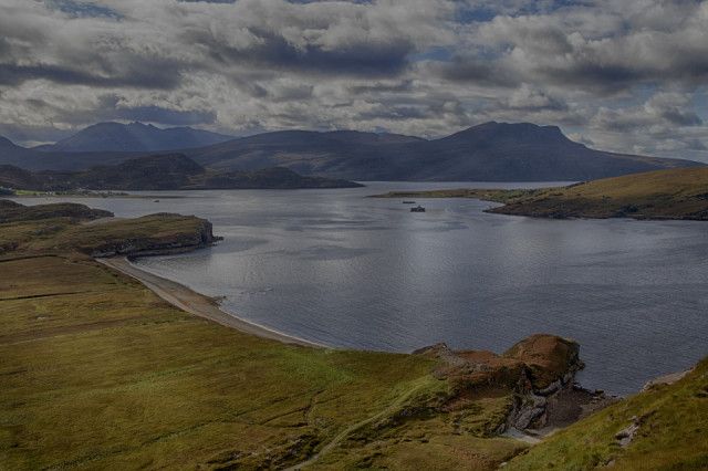
Continuing upwards I reached something of a plateau which is where I took my blip. In the background you can see An Teallach with crepuscular rays breaking through the cloud. To the left of the blip is the settlement of Ardmair. Moving across, the peak across the water is Bheinn Ghobhlach with the flank of Isle Martin just into view. Below me, you can see the Dun Canna Hill Fort with the beach to the left.
At this point I was planning to walk further along the Postie Path, but the next section went down and across a stream then traversed along the hillside opposite. I started down to the stream but it was hard going and it was here that sense prevailed. I had struggled enough getting to this point and if I continued I would have the same issues on a steeper, exposed route. Not a good place to turn an ankle. I turned back, regained the flat area and sat on a rock to eat my Tunnocks and wait for the sun to come out from behind the clouds again, before commencing my slow descent on my creaky knees.
Tony returned an hour or so after me having successfully walked up Cul Beag via a very steep and muddy route up loose, eroded sandstone. As we relax in front of the wood burning stove, the rain has begun again.
Comments
Sign in or get an account to comment.


