
Footpaths leading to the Weyhouse
When I got home after the market today, I walked down the garden for a breath of fresh air. Last year Helena and her sister Kate, and a couple of friends did heroic endeavours in the garden clearing so many areas of encroaching weeds, branches and bushes. It has brought the light back to areas which had become in shadow and today I could really appreciate how improved the garden is.
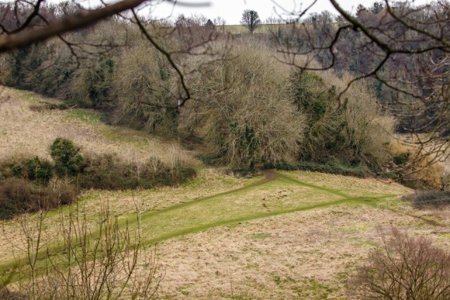
At the very bottom of the garden are some very old sycamore and ash trees marking our boundary, which then drops steeply down the hillside to the Lime Brook that has formed the bottom of The Horns valley, about forty yards below.
On the far side there is an interlocking spur between the Lime Brook and another stream running down from The Heavens, whose water first pours out of the limestone strata just below the summit. The lone tree in the far distance is only about a hundred yards from that spring. The land immediately behind it was part of the local 'open field' system in the Middle Ages. Down in the valley to the right there are still observable ridge and furrow markings in the fields, particularly in winter when the snow lies in the furrows.
Running down the spur is the ancient footpath, or ‘Wey’, that continues across the Golden Valley formed by the main River Frome and then on up to the old Iron Age encampment on Rodborough Common. Where the ‘Wey’ leaves the wood the path gradually becomes a hollow way which is hard to see from this angle. At this junction point an old farmstead was sited called ‘Weyhouse’, but it was destroyed by the farmer after the Second World War, probably to stop it being squatted. There were no other means of access. Several farm cottages in the wood above it were also flattened leaving only their rubble walls.
But the footpaths I’ve shown here are still very busy with local people now using the land for walking. The surrounding farmland is sadly neglected and the roaming cows which formerly would roam and graze there widely in the summer months have now been absent for several years and the land is reverting naturally to scrub. What a shame. This whole valley would have had very little chemical fertilisers at all so that the ecosystem is very healthy, and all less than a mile from the town centre.
When I saw the marks of these paths I decided to blip them as their marks on the ground will soon disappear as the grass grows up once again. The valley where the The Heavens stream flows down is locally nicknamed Happy Valley, and at the top of the meadows where the slope becomes steeper there is a wonderful little waterfall, which is very unusual in these Cotswold hills.
NB I've marked the point where I took the picture on the map.
Comments
Sign in or get an account to comment.


