
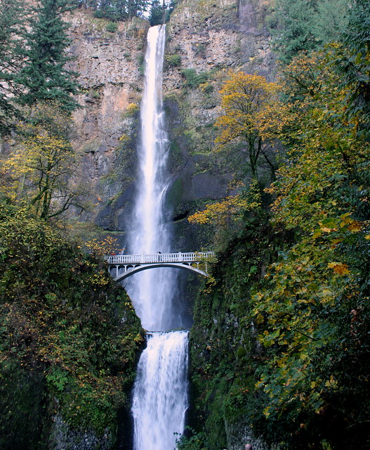
The One and Only Multnomah Falls
Actually, I was going to put up the view from Cape Horn. But, Bill and I ended up at Multnomah Falls, and well...how can I resist the jewel of Oregon waterfalls.
It was a lovely day today and I got into a royal snit because I've been looking forward to today to get out and about and one of our tires on the car decided to have a slow leak and because a bit of winter weather is on the horizon, a lot of people chose today to go get winter snow tires put on their car...and the wait to get our tire looked at was hours long. So, I thought we weren't going to get to take advantage of this lovely day, but we do have a pick-up, so we took it to Cape Horn and then down to the Bridge of the Gods and then back home via the Oregon side with a stop at the falls. Spoiled brat got her way. Hey, bad weather is coming...we won't be going ANYWHERE! Gotta take advantage. Bill was good with it all...so all is well. I might add that by changing cars and not knowing we would be at the falls, I didn't have my tripod. Rats.
And I learned a thing or two by looking up info on the Bridge of the Gods. And if you read Wild: From Lost to Found on the Pacific Crest Trail by Cheryl Strayed, which I highly recommend, you will see that this is where she ended her journey on the trail.
The Bridge of the Gods was a natural dam created by the Bonneville Slide, a major landslide that dammed the Columbia River near present-day Cascade Locks, Oregon in the Pacific Northwest of the United States. The river eventually breached the bridge and washed much of it away, but the event is remembered in local legends of the Native Americans as the Bridge of the Gods.
Greenleaf Peak and the Bonneville landslide from Bonneville Dam
The Bridge of the Gods is also the name of a modern manmade bridge, the Bridge of the Gods, across the Columbia River between Oregon and Washington.Interpretations of the age of the Bonneville landslide have evolved as more investigators have studied it and as more modern dating techniques have become available. Early work based on dendrochronology and radiocarbon dating suggested the landslide occurred between 1060 and 1180 or between 1250 and 1280. The year 1100 A.D. has often been cited as the date of the Bonneville landslide. More recent work using radiocarbon dating and lichenometry has suggested dates between 1500 and 1760 or between 1670 and 1760.[1][2] These younger radiocarbon ages permitted a possible a link to the 1700 Cascadia earthquake.[3][4] However, more recent investigations using radiocarbon dating and dendrochronology show the landslide occurred around 1450, more than two centuries before the great earthquake[5][6]
The Bonneville landslide sent a large amount of debris south from Table Mountain and Greenleaf Peak, covering more than 5.5 square miles (14 km2). The debris slid into the Columbia Gorge close to modern-day Cascade Locks, Oregon, blocking the Columbia River with a natural dam approximately 200 feet (61 m) high and 3.5 miles (5.6 km) long. The impounded river formed a lake and drowned a forest of trees for about 35 miles (56 km). Native Americans may have been able to cross the river on the dam or, as their oral histories say, a bridge. Although no one knows how long it took, the Columbia River eventually broke through the dam and washed away most of the debris, forming the Cascade Rapids.[4] Geologists have determined that debris from several distinct landslides in the same area overlap, forming what is called the Cascades landslide complex. The Bonneville landslide was the most recent, and perhaps the largest landslide of the complex. Understanding the nature of the landslide complex and mapping the lobes of individual landslide events was done during the 1960s and 1970s. The composite nature of the landslide complex may explain the early discrepancies between date estimates of the Bonneville Landslide.[6]
230
views
- 10
- 2
- Canon EOS REBEL T2i
- 1/33
- f/5.6
- 18mm
- 400
Comments
Sign in or get an account to comment.


