Puketapapa
Puketapapa is a volcanic scoria cone, which was formed by a fire fountaining eruption with lava flows about 20,000 years ago. An earlier explosive eruption had left an incomplete tuff ring that was all but obliterated by the more recent eruption, which produced two craters. The top of the hill (109m above sea level; the cone height is 55m) was relatively flat, hence the Te Reo name given by Maori. Puketapapa means flat topped hill.
According to archaeological evidence, Maori (from the Waiohua of Tamaki) occupied a Pa on this cone between 1430 and 1620. Although oral history suggested that the Pa was lost when the Waiohua were defeated by Ngati Whatua in the mid 18th century, the latest archaeological evidence of occupancy is around 50 years earlier than that. An alternative oral history does not mention Puketapapa as one of the Pa lost to Ngati Whatua in battle.
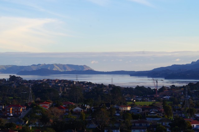
Because the Pa had extensive terracing and defences, plus many store pits, it seems more likely that it was abandoned by choice rather than defeat. As my photo shows, the outlook to the south west from the highest point of the cone, gives wide views of the Manukau Harbour. Equally good outlooks were possible in the opposite direction.
Ngati Whatua gained the rights to Puketapapa by defeating Waiohua Tamaki, although it appears they did not occupy it. In 1841, it was sold to the Crown by Ngati Whatua, and shortly afterwards the Crown sold it to Alexander Kennedy (a banker) who called the cone Mount Roskill after Roskhill on the Isle of Skye, where Kennedy came from. Only four years later, Kennedy sold the cone and surrounding land to Joseph May, who later became a Member of Parliament. After he died, his heirs sold it to George Winstone.
Winstone donated the cone and surrounding land to the people of Auckland in 1928, and in recognition the park at the base of the cone was called Winstone Park. Unlike many of the other scoria cones, Puketapapa was not subjected to extensive quarrying. At least until the 1960s, when a large pit was excavated on the flat top of the cone for a water reservoir. That was the covered over so that it is now underground. It is currently only used for emergency water supply.
Puketapapa is one of the about 50 volcanoes in the Auckland volcanic field. Rather than a photo of the cone, I have blipped the view over the Manukau Harbour, from the highest point.
Comments
Sign in or get an account to comment.


