
Stranded like a beached whale on the river bank
Having driven to pick up some fresh tofu, one of my favourite foods, from an Asian emporium in Gloucester, I drove away through the back streets of the city towards the nearest bridge over the Gloucester to Sharpness canal. I wanted to go to buy the wonderful organic milk, keffir and cream from Jess’s Ladies farm in Hardwicke.
The farm is isolated from main roads by the canal on its eastern side and the tidal River Severn a couple of miles to the west. As a result the area has a very quiet ‘atmosphere’ with limited visitors and narrow roads, many of which are single tracked. Having crossed Rea Bridge towards Stonebench, I took a slightly longer and meandering route which took me beside the river at times. I saw a road sign to ‘Weir Green (No through road)’, which immediately caught my attention so I drove down it to the end. After about half a mile the road ended at the protective flood bank, close to some old houses, where I managed to park.
I walked along the river bank for a few hundred yards downstream but found the abundance of tall shrubs, rushes, willows and other trees formed a rather impenetrable barrier to the water’s edge. I stopped for a few minutes under an old apple tree, of which there are quite a few on the banks probably having self-seeded from the formerly abundant fruit orchards, of which quite a few remnants survive along both banks of the river.
Light rain began to fall so during a lull I walked back to Weir Green and carried on walking in the opposite direction, along the Severn Way once again toiwards Gloucester city. Before long the path became impassible to someone like me in shorts as there were so many brambles and nettles. I could tell that not many people walk this way anymore. I returned to Weir Green and then looked back upstream, towards Gloucester and saw once again this odd sight of a stranded river boat high up on the top of the flood bank. I’d spotted its outline when I drove along the nearby road and wondered what it was and how it got there. I’m none the wiser.
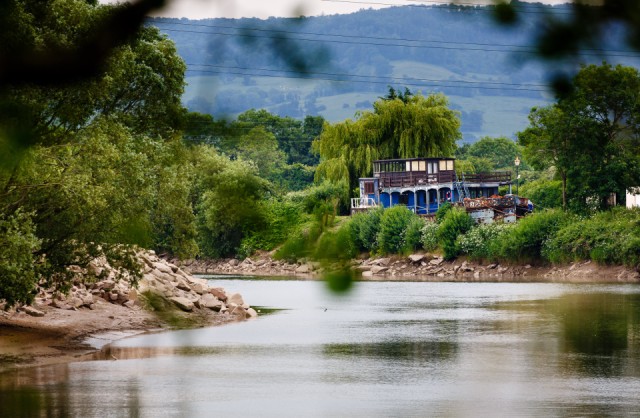
I have checked local history sites but there is no mention of the boat. From a Google Map aerial view I could see it in the grounds of Stonebench Manor. The area has a rich mix of both late Medieval A-frame cruck buildings, some of which are still thatched, as well as early Georgian and later brick built farm related buildings.
There is no weir at Weir Green, however, it was once a small port for the delivery of coal and other goods from the Forest of Dean, which might serve to explain it’s original name of “Ware Lane”. This was before the Sharpness canal was built in the 1840s to allow sea-going boats to reach the port of Gloucester. Gloucester Docks are a remarkably complete example of a Victorian port, which was very busy at one time, and it is the furthest inland port in the country. Cargoes were transferred onto smaller narrowboats at the docks for transporting further up the river and through the canal system to supply the growing industrial towns of the Midlands. Nowadays, the docks are mostly used by pleasure craft and the occasional yacht or tall ship. A number of fine warehouses line the docks, where ships once unloaded their cargoes.
In this view you can see the apex of 'the outer curve of the horseshoe meander of the River Severn where stands the hamlet of Stonebench, which was the most popular place for sightseers to view the Severn Bore. It takes its name from the ledge of hard rock running across the bed of the river. This submerged rock has the effect of combing the mane of the Severn Bore into a finer crest, and at one time the Stonebench was used as a ford, though a dangerous one' (with thanks to Brian Waters' wonderful book, 'Severn Tide', first published in 1947).
You can see the great size of the tidal range as I shot this near to, but not quite at the low tide. The tidal bore fills the river and more, often flooding over the banks onto the neighbouring fields at a 'big Bore'. The distant hills are the west-facing escarpment of the Cotswold Hills, beyond Gloucester. The Roman Road from Cirencester to Gloucester crossed these hills close to this point at Birdlip.
Comments
Sign in or get an account to comment.


