And now, the conclusion
The first couple of post-holiday days are always a bit of an anticlimax, and since it was raining and blowing a gale all morning and most of the afternoon, I didn't go anywhere except the kettle, my bookcase and my computer, and sorted out all the hi-techery from the past few days and read about hovercraft history.
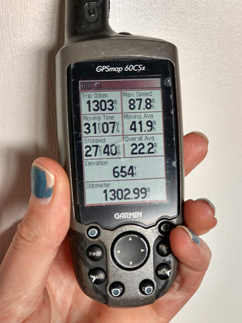
When I cycled the Erie Canal in 2009, my friend had an early Garmin GPS and he recorded the whole route we took. I thought that was absolutely amazing, and a year later I bought myself this one not only to help tell me where to go but also where I went. I've used the absolute heck out of it since, as you can see by the way I've worn the print off the buttons. Although it's more a backup now to my not-a-phone GPS which runs the satnav app and a separate data logger app, it's tough and has a few tricks up its sleeve, like punching in waypoints on the move. Buttons are still better than touchscreens when going by feel.
The top speed reported here I thought must be an imaginary number, but apparently I did reach that speed for a moment. I was probably either trying to escape some tailgating driver or was in hot pursuit of Biscuit going at ludicrous speed. I also had the Garmin running when we nipped over to the Isle of Wight, and the hovercraft was fairly shifting, too.
But the best number is top-left, and we have 1303 miles ridden. Actually it was 1336 miles, because the thing went flat at some point. But, good grief that's a lot of miles!
123
views
- 6
- 0
- Motorola moto g(8) power
- 1/33
- f/2.4
- 6mm
- 323
Comments
Sign in or get an account to comment.


