
Rock House
Saturday
Hocking Hills is a land of deep gorges, rock outcrops and waterfalls. The scenery owes its classic characteristics to a number of circumstances. More than 330 million years ago, the Hocking Hills State Park area was relatively level and covered by the waters of the Atlantic Ocean. For millions of years, the ocean’s currents deposited immense amounts of sand and gravel. Eventually, the ocean receded, and the sandy layers bonded with silica to form the Black Hand Sandstone that underlies the area. It formed like a sandwich, with a hard top and bottom and a soft middle layer. The next significant changes occurred when the Appalachian Mountains arose. Hocking Hills State Park was hemmed in by the ancient north-flowing Teahs River to the west, and the then north-flowing Hocking to the east. The landscape remained fairly static for further millions of years, then finally when the Wisconsin Glacier began melting back to the north about 10,000 years ago, the landscape would undergo dramatic changes. The glacier stopped in northern Hocking County, so the area suffered indescribable flooding. The ancient Teahs River was buried under tons of glacial silt, and the direction of the Hocking River was reversed. When the glacial torrents found cracks in the hard capstone, the water poured through to flush out the soft middle layer. This left long tunnels where the gorges are today. Eventually, the weight of the tops caused them to come crashing down. The "slump rocks" in the gorges today are what's left of the hard top layer. In just a few centuries, the rushing waters of the glacier carved the soft middle layer of sandstone into the myriad dimples and wrinkles that decorate the cliffs and grottos today.
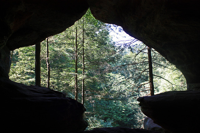
This morning we walked from Cedar Falls to Ash Cave, about five miles return. Whilst the temperatures are a little lower here than back in Cincinnati, (probably upper 80s, as opposed to low 90's) and you're in shade most of the time, it was still quite tiring, especially as I hadn't slept very well! But I survived, and we returned to the campground for lunch. Then in the afternoon we headed out for a shorter walk at Rock House. Rock House is the only true cave amidst the formations, Ash Cave and Old Man's Cave actually being huge recess caves. It is a tunnel-like corridor situated midway up a 150-foot cliff of Blackhand sandstone. The ceiling is 25 feet high, while the main corridor is 200 feet long and 20 to 30 feet wide. The cavern was eroded out of the middle zone of the Blackhand sandstone. Water leaking through a horizontal joint running parallel to the cliff face caused the hollowing of the corridor. This main joint or crack is very visible in the ceiling. A small series of joints run at right angles to the main joint, and enlargement of this series of joints over the years formed the seven window-like openings of Rock House.
One year ago: Sunset
Comments
Sign in or get an account to comment.


