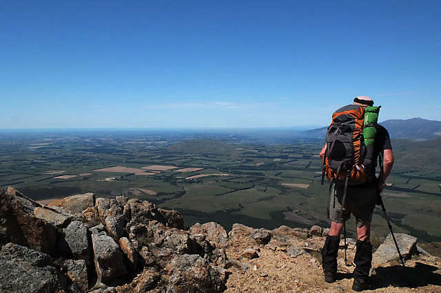
I can see for miles and miles
A perfect day albeit a tad too hot out in the open in temperatures in the mid-plus 30s.
A perfect view and definitely worth viewing large
Perfect weather-wise, interesting otherwise and ultimately an enjoyable day. It started well. We made good time up the track and onto the route up a broad ridge we planned would take us to the summit of Mt Somers.
When we stopped for a break 2+ hours up I suggested we get the map out. Silence. JT forgot it and didn't mention it until I asked. We were further up than down, not a cloud in the sky and we figured once we got a bit further up we'd clearly see the summit before us.
Eventually we did see the summit. Only without the map we had wasted precious time and fluids heading in the wrong direction. We changed course and I decided we'd see where we were in relation to the base of the final push to the summit in half an hour.
We sat and had a snack and a few swigs of the 2 L each we were carrying of water with electrolytes. JT admitted he'd had enough and said he'd wait while I went up to the summit.
Tempting and do-able but I was stressed being in an alpine environment - even on a fine, sunny hot day without a map. Separating wasn't the answer. It will still be there another day. The next question was how to to get down. We had a frank discussion.
There are 2 popular routes one we should in theory cross and pick up. We were on a huge sloping plateau peppered with large rocks mostly hidden by giant tussocks. Not easy ground. We agreed to check the south east edge, mindful of bluffs and steep gullies.
We checked apparent cairns and rocky outcrops. No sign of the route. A perfect day but I was feeling stressed as I calculated how long we'd be ok with no shade in hot temperatures. We discussed whether to to descend a long slope in the hope we'd pick up a route and eventually a track lower down. Or should we retrace our route down the ridge we'd come up? The latter was definitely longer but we knew what we'd find. The former potentially shorter and closer to water but with no guarantee we'd find a route and eventually a track.
JT gave me 2 votes but urged me to go with the descent of the long slope. I trusted him and he was right. We stopped part way down and squeezed into a straggly scratchy bush for a meager shaded lunch. We assessed how much liquid we each had left, had a good top up and a wee nibble.
As we sat we picked up on a distant track and then spotted 2 tiny distant figures. We still had some rough ground to cover but we now knew we had 2+ hours to make our remaining liquid last.
We were never in danger and with a combination of straight talking and teamwork made for an excellent outcome. JT had prearranged to call a friend if we needed picking up on the wrong side of Mt Somers from the car. He made that call at lunch and his friend was happy to come and ferry us from one side to the other where the car was.
Once down the 3 big cups of water from the stream we each downed were the best. We poured water over our heads and cooled down our legs and arms. To see JT cooling and reviving was great. His friend bought lemonade and once we'd got our clean change of clothes from the car, we had iced coffee at the Staveley store.
Next time any missing map will be mentioned early on and another option taken. We're still good mates, a good learning experience, a thoroughly enjoyable trip and I delivered JT safely home to his wife :-)
180
views
- 0
- 0
- Fujifilm X10
- f/11.0
- 7mm
- 800
Comments
Sign in or get an account to comment.


